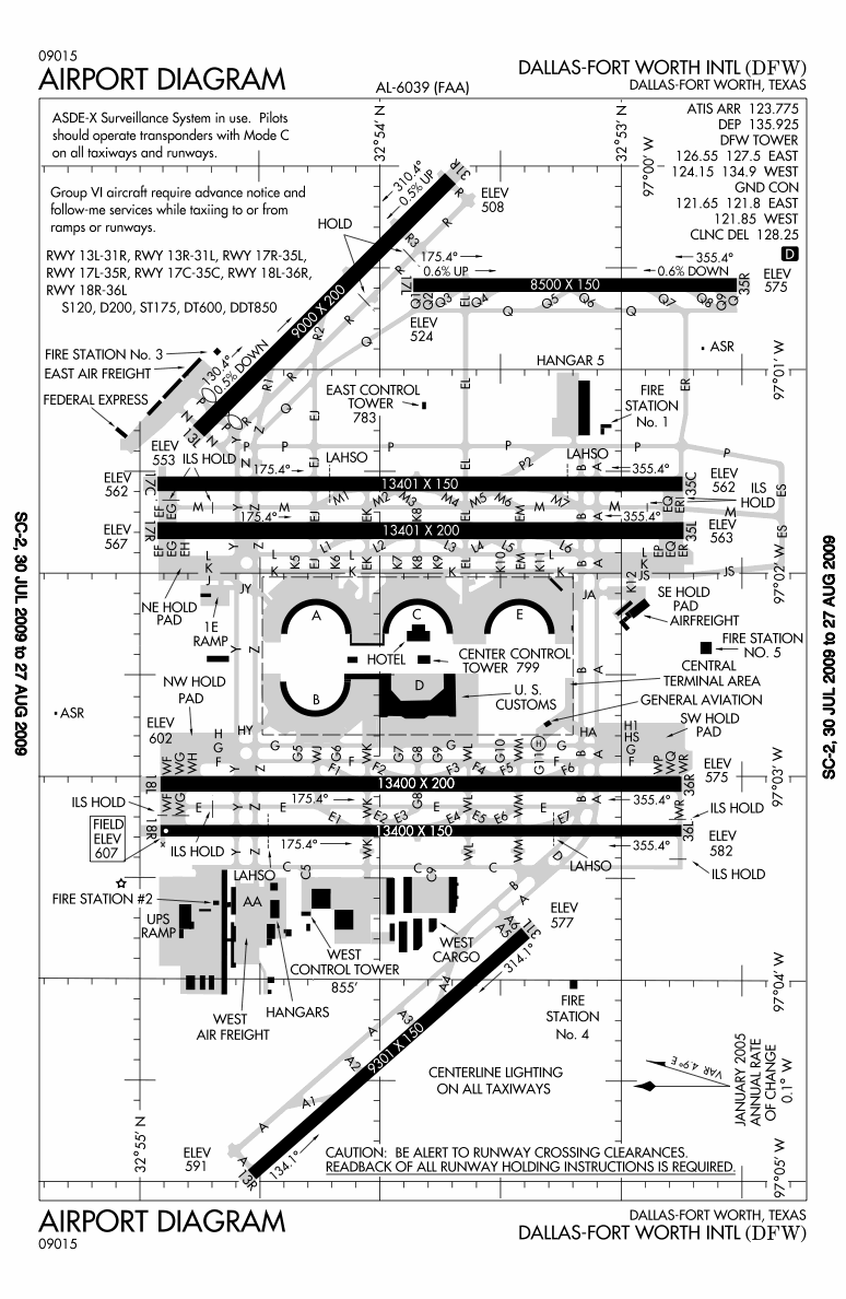
In the first part of this two part series on airport runways, we covered the basics of runway terminology, runway numbering, etc.
Today we focus on the runway itself. The sections and parts of the runway, and terms very few outside the core aviation industry know significant details about.
Common measurement terms
Apart from the length and width of the runway, pilots depend on some key runway data.
TORA - TakeOff Run Available i.e. the length of runway declared available and suitable for the ground run of an airplane taking off.
LDA - Landing Distance Available i.e. the length of runway which is declared available and suitable for the ground run of an airplane landing.
Sections of the runway
This is a generic drawing of a runway.
 The area marked with yellow chevrons (V shapes) are the blast pads, also referred to as overrun areas or stopways. These areas are often constructed before the start of a runway to reduce the erosion of earth by the jet blast produced by large planes when they power up for take-off (the GE90-115B found on all Boeing 777-300ERs produces over 115,000 lbs of force at full power). Overrun areas can also be used by landing aircraft as an emergency stopping space. Blast pads are often not as strong as the main paved surface of the runway and aircraft are not allowed to use it except in extreme emergencies.
On precision instrument runways which have an ILS system i.e. at most medium and large airports in the world in addition to the blast pad/stopway there are markings for threshold, designator, centerline, aiming point, and 500 ft (152 m), 1,000 ft (305 m)/1,500 ft (457 m), 2,000 ft (610 m), 2,500 ft (762 m), and 3,000 ft (914 m) touchdown zone marks. The are variations from country to country on runway marking.
The main parts of the runway are detailed in the diagram below. The threshold is essentially the start or end of the actual runway itself. The touch down zone is the target area for pilots to stick the wheels of their aircraft on to the runway.

Many a time, one can find a displaced threshold. A displaced threshold is a runway threshold located at a point other than the physical beginning or end of the runway.
 Displaced thresholds are marked with V head arrow marks before the threshold of the runway. Displaced thresholds are normally implemented when there is an encroachment in the landing path (typically outside the airport) that prevents aircraft from touching down at the start of the runway when descending at a normal three degrees angle.

To clear the obstruction the actual threshold is displaced or moved forward or the angle of descent is increased. The portion of the runway in the displaced threshold may be used for takeoff but not for landing. If there is a displaced threshold on the opposite side of the runway, landing aircraft may use the displaced area on the opposite end for roll out and stopping. If the angle of descent is increased beyond three degrees then the runway cannot be qualified for low visibility operations other than Cat I ILS.
The most famous case of displaced threshold in India is at the newest runway 11-29 of New Delhi's Indira Gandhi International airport whose threshold is displaced by a mind numbing 1,610m reducing LDA to only 64% of the total runway length, thanks to encroachments. In Mumbai where there is no space for extending the runway, the glide slope is increased to clear obstacles and hence the runway is limited to Cat I ILS visibility norms and has to stop operations in periods of extremely low visibility.
Runway lighting
In a globalised world most airports today operate 24x7 or at least from dawn well in to the night.
Runway lighting which allows for operations in the dark or at times of low visibility forms an integral part of any runway at a modern airport.
Most runways will have some if not all, of the below lighting systems.
Approach Lighting System (ALS) – the lighting system installed on the approach end of a runway consisting of a series of lightbars, strobe lights extending outward from the runway end.
Runway End Identification Lights (REIL) – unidirectional facing approach direction or omnidirectional pair of synchronized flashing lights (normally two yellows blinking alternately) installed at the runway threshold, one on each side.
Runway end lights – lights on each side of the runway on precision instrument runways, extending along the full width of the runway showing green when viewed by aircraft approaching to land and red when seen from the runway.
Runway edge lights – white elevated lights that run the length of the runway on either side. On precision instrument runways, the edge-lighting becomes yellow in the last 2,000 ft (610 m) of the runway as an alert to pilots. Active runways are always marked with white lights. No other aircraft path at an airport may use white lighting.
Taxiways have blue colour edge lights, and modern airports have green centre lights. Of course this is dependant on the width of the taxiway, and the complexity of the taxiway pattern.
Confusion over lighting was at the centre of the controversy following the crash of Singapore Airlines Flight 006 at Taipei, Taiwan on 31 October 2000.
Runway Centerline Lighting System (RCLS) – white lights embedded along the centre-line the runway at 50 ft (15 m), except the last 3,000 ft (914 m), where red is alternated with white for next 2,000 ft (610 m) and red for last 1,000 ft (305 m). RCLS is optional for ILS Cat I but mandatory for ILS Cat II and Cat III.
Touchdown Zone Lights (TDZL) – rows of bars of three white lights on either side of the centerline over the first 3,000 ft (914 m) of the runway, or to the midpoint in case the runway is less than 6,000ft (1,828 m).
Taxiway Centre-line Lead-Off Lights – installed to indicate turn-offs for taxiways, alternate green and yellow lights, starting at the runway centre-line and curving to the first centre-line light beyond holding position on the taxiway.
Taxiway Centre-line Lead-On Lights – installed the same way as taxiway centre-line lead-off Lights.
Land and Hold Short Lights – a row of white pulsating lights installed across the runway to indicate hold short position on some runways which are facilitating land and hold short operations (LAHSO).
PAPI
While not part of the runway lighting system per se, almost all passengers have seen four red lights by the side of the runway. These are Precision Approach Path Indicators (PAPI) used in conjunction with the ILS for ensuring a smooth descent in line to the runway. The initial wrong installation of the PAPI at Bengaluru International Airport and Rajiv Gandhi International Airport and its resultant impact on airport operational efficiency is covered in this article by Capt. Ranganathan an airline instructor pilot on Boeing 737 with a flying experience of 20,000 hrs. The re-alignment of the ILS and the PAPI runway 27 at Bangalore has been completed and runway 09 should be completed very soon.
Runway Construction, PCN, ACN
Most modern runways are constructed using concrete. In areas not susceptible to freezing weather, post-tensioned concrete allows for thinner slabs.
Runways have to be extremely strong. An Airbus A380 weighs about 380 tonnes (about 32 fully loaded trucks) and lands at a speed of 300 kmph. At take off the aircraft weighs 560 tonnes. The forces involved just scramble the mind.
Runway strength is measured in Pavement Classification Number (PCN) which is an International Civil Aviation Organization (ICAO) standard. Bengaluru International Airport runway 09-27 has a PCN of 80 F/B/W/T which means means that the pavement has a bearing strength of 80, it is flexible (F) made of asphalt, it is on a medium sub-grade (B), has no limit on tire pressure (W), and this has been calculated through technical evaluation (T).
PCN is used in combination with the Aircraft Classification Number (ACN) which indicates the load a particular aircraft exerts on to the pavement, to help ensure that the airport runways, taxiways, and ramp are not subjected to excessive wear and tear. The Airbus A380 superjumbo has an ACN of 68 for medium sub-grade pavements.
Runway pavement surfaces are made and and maintained to maximize friction for best possible braking performance. To minimize hydroplaning following heavy rain, the pavement surface is usually grooved. Very high quality drainage is also a must to prevent water from stagnating on the surface. A runway which has patches of standing water is considered contaminated.
To maintain this surface, airports perform routine maintenance where crews remove the tyre rubber that accumulates and also re-mark the runway surfaces as required. Bengaluru International Airport has a very strong runway maintenance regime.
I hope this primer has been of help. Feel free to ask questions, leave comments, praise or brickbats. If you would like any other topic covered, please do let all Bangalore Aviation readers know via a comment.
Read more »
Today we focus on the runway itself. The sections and parts of the runway, and terms very few outside the core aviation industry know significant details about.
Common measurement terms
Apart from the length and width of the runway, pilots depend on some key runway data.
TORA - TakeOff Run Available i.e. the length of runway declared available and suitable for the ground run of an airplane taking off.
LDA - Landing Distance Available i.e. the length of runway which is declared available and suitable for the ground run of an airplane landing.
Sections of the runway
This is a generic drawing of a runway.

On precision instrument runways which have an ILS system i.e. at most medium and large airports in the world in addition to the blast pad/stopway there are markings for threshold, designator, centerline, aiming point, and 500 ft (152 m), 1,000 ft (305 m)/1,500 ft (457 m), 2,000 ft (610 m), 2,500 ft (762 m), and 3,000 ft (914 m) touchdown zone marks. The are variations from country to country on runway marking.
The main parts of the runway are detailed in the diagram below. The threshold is essentially the start or end of the actual runway itself. The touch down zone is the target area for pilots to stick the wheels of their aircraft on to the runway.

Many a time, one can find a displaced threshold. A displaced threshold is a runway threshold located at a point other than the physical beginning or end of the runway.
 Displaced thresholds are marked with V head arrow marks before the threshold of the runway. Displaced thresholds are normally implemented when there is an encroachment in the landing path (typically outside the airport) that prevents aircraft from touching down at the start of the runway when descending at a normal three degrees angle.
To clear the obstruction the actual threshold is displaced or moved forward or the angle of descent is increased. The portion of the runway in the displaced threshold may be used for takeoff but not for landing. If there is a displaced threshold on the opposite side of the runway, landing aircraft may use the displaced area on the opposite end for roll out and stopping. If the angle of descent is increased beyond three degrees then the runway cannot be qualified for low visibility operations other than Cat I ILS.
The most famous case of displaced threshold in India is at the newest runway 11-29 of New Delhi's Indira Gandhi International airport whose threshold is displaced by a mind numbing 1,610m reducing LDA to only 64% of the total runway length, thanks to encroachments. In Mumbai where there is no space for extending the runway, the glide slope is increased to clear obstacles and hence the runway is limited to Cat I ILS visibility norms and has to stop operations in periods of extremely low visibility.
Runway lighting
 | |
| Runway 28 lighting at IGI airport, New Delhi, India. |
Runway lighting which allows for operations in the dark or at times of low visibility forms an integral part of any runway at a modern airport.
Most runways will have some if not all, of the below lighting systems.
Approach Lighting System (ALS) – the lighting system installed on the approach end of a runway consisting of a series of lightbars, strobe lights extending outward from the runway end.
Runway End Identification Lights (REIL) – unidirectional facing approach direction or omnidirectional pair of synchronized flashing lights (normally two yellows blinking alternately) installed at the runway threshold, one on each side.
Runway end lights – lights on each side of the runway on precision instrument runways, extending along the full width of the runway showing green when viewed by aircraft approaching to land and red when seen from the runway.
Runway edge lights – white elevated lights that run the length of the runway on either side. On precision instrument runways, the edge-lighting becomes yellow in the last 2,000 ft (610 m) of the runway as an alert to pilots. Active runways are always marked with white lights. No other aircraft path at an airport may use white lighting.
Taxiways have blue colour edge lights, and modern airports have green centre lights. Of course this is dependant on the width of the taxiway, and the complexity of the taxiway pattern.
Confusion over lighting was at the centre of the controversy following the crash of Singapore Airlines Flight 006 at Taipei, Taiwan on 31 October 2000.
Runway Centerline Lighting System (RCLS) – white lights embedded along the centre-line the runway at 50 ft (15 m), except the last 3,000 ft (914 m), where red is alternated with white for next 2,000 ft (610 m) and red for last 1,000 ft (305 m). RCLS is optional for ILS Cat I but mandatory for ILS Cat II and Cat III.
Touchdown Zone Lights (TDZL) – rows of bars of three white lights on either side of the centerline over the first 3,000 ft (914 m) of the runway, or to the midpoint in case the runway is less than 6,000ft (1,828 m).
Taxiway Centre-line Lead-Off Lights – installed to indicate turn-offs for taxiways, alternate green and yellow lights, starting at the runway centre-line and curving to the first centre-line light beyond holding position on the taxiway.
Taxiway Centre-line Lead-On Lights – installed the same way as taxiway centre-line lead-off Lights.
Land and Hold Short Lights – a row of white pulsating lights installed across the runway to indicate hold short position on some runways which are facilitating land and hold short operations (LAHSO).
PAPI
While not part of the runway lighting system per se, almost all passengers have seen four red lights by the side of the runway. These are Precision Approach Path Indicators (PAPI) used in conjunction with the ILS for ensuring a smooth descent in line to the runway. The initial wrong installation of the PAPI at Bengaluru International Airport and Rajiv Gandhi International Airport and its resultant impact on airport operational efficiency is covered in this article by Capt. Ranganathan an airline instructor pilot on Boeing 737 with a flying experience of 20,000 hrs. The re-alignment of the ILS and the PAPI runway 27 at Bangalore has been completed and runway 09 should be completed very soon.
Runway Construction, PCN, ACN
Most modern runways are constructed using concrete. In areas not susceptible to freezing weather, post-tensioned concrete allows for thinner slabs.
Runways have to be extremely strong. An Airbus A380 weighs about 380 tonnes (about 32 fully loaded trucks) and lands at a speed of 300 kmph. At take off the aircraft weighs 560 tonnes. The forces involved just scramble the mind.
Runway strength is measured in Pavement Classification Number (PCN) which is an International Civil Aviation Organization (ICAO) standard. Bengaluru International Airport runway 09-27 has a PCN of 80 F/B/W/T which means means that the pavement has a bearing strength of 80, it is flexible (F) made of asphalt, it is on a medium sub-grade (B), has no limit on tire pressure (W), and this has been calculated through technical evaluation (T).
PCN is used in combination with the Aircraft Classification Number (ACN) which indicates the load a particular aircraft exerts on to the pavement, to help ensure that the airport runways, taxiways, and ramp are not subjected to excessive wear and tear. The Airbus A380 superjumbo has an ACN of 68 for medium sub-grade pavements.
Runway pavement surfaces are made and and maintained to maximize friction for best possible braking performance. To minimize hydroplaning following heavy rain, the pavement surface is usually grooved. Very high quality drainage is also a must to prevent water from stagnating on the surface. A runway which has patches of standing water is considered contaminated.
To maintain this surface, airports perform routine maintenance where crews remove the tyre rubber that accumulates and also re-mark the runway surfaces as required. Bengaluru International Airport has a very strong runway maintenance regime.
I hope this primer has been of help. Feel free to ask questions, leave comments, praise or brickbats. If you would like any other topic covered, please do let all Bangalore Aviation readers know via a comment.